17
Discover Smith Mountain Lake
SUMMER 2016
16
1966
A DREAM CAME
TRUE IN
The idea of building a dam in the Smith Mountain gap
had been tossed around as early as the 1920s.Appalachian
Power Company (APC) needed the water source to make
electricity, and local governments wanted to preserve
resources by preventing damaging floods.
The name “Roanoke” is derived from an Algonquian word
“rawrenok” which means “wampum”. Due to deadly
Spring floods the Roanoke River also earned the name
“River of Death”.
The US Corps of Engineers developed plans to build as
many as 17 dams to harness the streams in the Roanoke
River basin.Their proposal went before the US Congress
in 1934 but, probably due to the price tag, it died quietly
in one house of Congress or the other, even though then-
president Franklin Roosevelt was a staunch advocate of
such projects.TheTennesseeValley Authority had been
created just a year earlier.
Then, in the late summer of 1940, when our nation had
not yet fully recovered from the Great Depression, and
the threat of involvement in a worldwide war loomed,
natural disaster struck.Tropical storms pounded this area,
causing one of the worst floods inVirginia’s history.Along
the 410 mile stretch of the Roanoke River, some 10,000
acres of cropland were destroyed, and large numbers of
livestock swept away. Homes were lost. Industry suffered,
as water levels rose a shocking 40 plus feet in towns on
the Southside and in North Carolina.
The cost to an already poor and struggling area of the
country was staggering.The good news was that the
devastation caused by the flood got the attention of
Congress. Legislators instructed the Corps of Engineers
to dust off and update their plans.
In 1944 the Pick-Sloan Flood Control Act was passed,
which included the construction of a $36 million dam
at Buggs Island and Philpott.The Buggs Island project
alone cost close to $100 million by the time construction
was completed in 1953. Officially, the Buggs Island dam
was named John H Kerr in honor of the North Carolina
congressman who championed the project.Virginians,
however, still call it Buggs Island.
2
The Corps’ plans for the Roanoke basin ultimately evolved
into six dams, which were built over the next two decades:
Kerr/Buggs Island, Gaston, Roanoke Rapids, Smith
Mountain, Leesville and Philpott. Buggs Island was the
biggest project, and the lynchpin to controlling the culprit
streams.
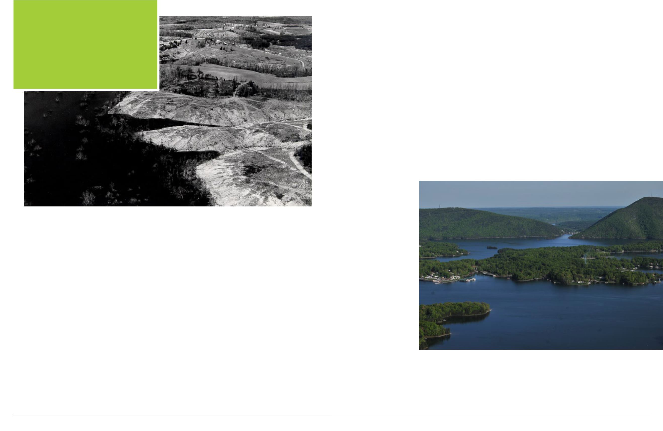
APC began construction on the Smith Mountain and
Leesville dams in 1960. One of the first steps in the
process was to temporarily divert the Roanoke River while
construction of the two dams took place.This was a major
accomplishment in itself. Hundreds of workers cleared
hundreds of thousands of cubic yards of mountainside until
they reached bedrock upon which the new dams would be
built.The dirt, rock and sediment they stripped from the
river bed was used as a buffer to divert the river. A mixing
plant was constructed at the site to prepare the 300,000
cubic yards of concrete that would be needed to build Smith
Mountain dam.A second such plant was built at Leesville
for the construction
of that dam.Although
both dams are made
of concrete and steel,
hundreds of thousands
of feet of lumber and
plywood were needed
to build the forms that
held the concrete until
it cured.The turbines
that were installed in the
dam were too large to
be shipped, so they had
to be constructed at the
site.
The Smith Mountain
Dam is a double
curvature arch type,
that spans 816 feet and
rises 227 feet above
the bed of the Roanoke
River, making it the tallest arched dam in the nation east of
the Mississippi.Water flows through the dam and past the
turbines, producing electricity during peak demand times.
This supplements the power generated by conventional
power plants, in order to satisfy the peak demands of the
more than 5 ½ million people from Michigan to North
Carolina who depend on the American Electric Power
(AEP) network for their electricity.AEP and APC are the
same company, called by different names depending on the
area they are serving.
Water released from SML is caught 17 miles downstream
at Leesville, where it is stored until time of least demand.
During these off-peak usage times, the turbines in both
dams are stopped and reversed.They then become pumps,
using the surplus power being produced by conventional
power plants during the time of low demand, pushing
the stored water back into SML.This process effectively
stores 440,000 kilowatts of electricity, seven times what
the normal flow of the river and a conventional dam would
create.
After the dam was completed in 1963,APC also built five
new bridges to accommodate traffic around the future lake,
and relocated many roads that would be cover once the lake
filled. Combined, SML and Leesville Lake are almost 60
miles in length, cover about 25,000 surface acres, and have
some 600 miles of shoreline. Smith Mountain Lake reached
full pond at 5:03 am on March 7, 1966.


